
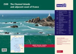
Description
Cap Barfleur to Alderney (1: 150 000) Plans Cherbourg (1:40 000) Port de Chantereyne (Cherbourg) (1:10 000)
3. Alderney & Burhou (1: 25 000) Plan Alderney Harbour (1:12 500)
4. Passages Between Alderney & Guernsey (1: 150 000) Plan Diélette (1:15 000)
5. Guernsey, Herm & Sark (1: 60 000)
6. East Guernsey & Herm (1: 25 000)
7. Guernsey & Sark Plans (various scales) Plans St Peter Port & Havelet Bay (1:6000) Beaucette Marina (1:10 000) Sark Anchorages (1:25 000) Guernsey – South Coast Anchorages (1:25 000)
8. Passages Between Guernsey & Jersey (1: 150 000) Plan Carteret (1:22 500)
9. Jersey & Les Écrehou (1: 75 000)
10. Approaches to St Helier (1: 30 000) Plan St Helier Harbour (1:15 000)
11. East Coast of Jersey (1: 25 000)
12. Jersey to Granville (1: 150 000) Plan Granville (1:30 000)
13. Plateau des Minquiers (1: 50 000)
14. Plateau des Minquiers to St-Malo (1: 150 000) Plan St-Malo Approaches (1:55 000)
15. Îles Chausey (1: 25 000)
16. St-Malo & La Rance (1: 15 000)
17. La Rance – Cancaval to Lyvet (1: 25 000)
For this edition the latest depth surveys have been applied. There has been general updating throughout. This edition has tidal stream information is included.
Imray Digital Charts: Free mobile download
A voucher code to download the relevant Imray digital charts into our Imray Navigator app is included with this atlas.
Reviews
There are no reviews yet.